On the topographic map below, write the appropriate number (1 through 4) to show the position on the map of each of the following features: #1-The cliff on the left hill. #2-The broad river valley in the center of the figure. #3The top of the rounded hill on the right. #4-The small depression to the right of the river valley, part way up the rounded hill.
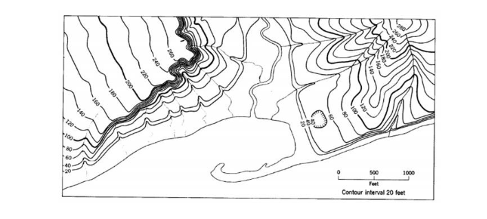
Look at the numbered features on the topographic map, Figure 1-6 (the first page of the worksheets). Identify the numbered topographic features in the table below. Possibilities include butte, ridge, mesa, narrow canyon, flat area, cliff, depression, mountain range, broad valley. Definitions for some of these terms are below. Feature Number Type of Feature Some simple definitions: Broad Valley-A valley that has a wide, gently sloping floor Butte-A hill or very small mountain that has steep sides or cliffs all around. Cliff-A high, very steep to vertical rock face Canyon A large and generally narrow valley with steep sides Depression A feature, commonly bowl-shaped, that is lower than surrounding areas Mesa A broad, flat-topped hill surrounded by cliffs and capped with a resistant rock layer Ridge-One or more hills that form a continuous high area flanked by sloping sides
The Correct Answer and Explanation is :
To accurately answer this question, I’ll provide guidance for identifying and labeling the features based on the topographic map and the provided definitions.
Step 1: Label the features on the map
- The cliff on the left hill:
- Look for closely spaced contour lines on the left hill, which indicate a very steep or vertical slope. Label this as #1.
- The broad river valley in the center of the figure:
- Look for widely spaced contour lines in the center, indicating a gentle slope and wide, flat terrain. Label this as #2.
- The top of the rounded hill on the right:
- Look for a closed contour loop on the right, which marks the hilltop. Ensure it is the highest elevation point on the hill. Label this as #3.
- The small depression to the right of the river valley, partway up the rounded hill:
- Look for a closed contour loop with hachure marks inside (short lines pointing inward), indicating a depression. This is partway up the right hill. Label this as #4.
Step 2: Identify the features in the table
Based on the labeled map:
| Feature Number | Type of Feature |
|---|---|
| 1 | Cliff |
| 2 | Broad Valley |
| 3 | Rounded Hilltop |
| 4 | Depression |
If you provide a screenshot or clearer details about the topographic map, I can verify the identification and refine the labels further!