The Correct Answer and Explanation is:
Of course. Here is the correct matching for the labels on the weather map, followed by a detailed explanation.
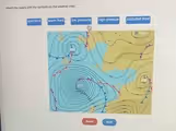
Correct Matches:
- Low Pressure: The large, circular weather system on the left side of the map, characterized by tightly packed, concentric lines (isobars).
- High Pressure: The weather system on the right side of the map, where the isobars are very far apart.
- Cold Front: The blue line with pointed triangles.
- Warm Front: The red line with rounded semi-circles.
- Occluded Front: The purple line with alternating triangles and semi-circles on the same side, wrapping around the center of the low pressure system.
Explanation:
This weather map displays several key meteorological features used for forecasting. The solid lines are called isobars, which connect points of equal atmospheric pressure.
The low pressure system, often marked with an “L,” is an area where the atmospheric pressure is lower than its surroundings. On the map, this is shown by the isobars being packed closely together, indicating a steep pressure gradient and strong winds. In the Northern Hemisphere, wind circulates counterclockwise and inwards toward the center of a low pressure system. The air then rises, cools, and condenses, which is why low pressure systems are associated with clouds, precipitation, and stormy weather.
Conversely, the high pressure system, often marked with an “H,” is an area of higher pressure. The isobars are spread far apart, signifying a weak pressure gradient and calm, light winds. Air in a high pressure system sinks and flows outward in a clockwise direction. As the air sinks, it warms and dries, inhibiting cloud formation. This typically brings fair, clear, and stable weather conditions.
The colored lines represent fronts, which are boundaries separating different air masses. A cold front is a blue line with triangles pointing in the direction of movement. It marks the leading edge of a colder air mass advancing on a warmer one, forcing the warm air to rise rapidly. This process often creates intense, short-lived thunderstorms. A warm front, the red line with semi-circles, shows a warmer air mass advancing and gently gliding over a colder one, usually resulting in widespread, steady, and lighter precipitation. Finally, an occluded front occurs when a faster cold front overtakes a warm front. This lifts the warm air completely off the ground and often marks the most mature stage of a storm, bringing complex weather patterns.